Mt. Kilimanjaro - Machame Route, Kilimanjaro National Park
Location : Tanzania
Distance : 100km (62km up, 38km down)
Duration : 6 days
Difficulty : strenuous
Time Zone : GMT+3
Present : Deneille Jacobs, Rudolf du Toit, Alan Webber, Tarryn Kearns, Ivor Norval, Lynn Elliot, Donna Burger, Willie van der Merwe, Ian Harrison, Wolfgang Marnitz, Richard Lord
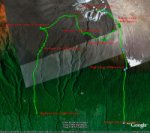
Kilimanjaro's Uhuru Peak is 5895m above sea level. There are various routes one can take up to the peak. The easy routes like the Marangu route are called the "Coca-Cola" routes and the more difficult routes are called the "Whiskey" routes. We took the MACHAME route, which is considered a "Whiskey" route. There are no huts to sleep in, only tents. The route is however rated as one of the most scenic routes and there are two added bonusses. The one is that the ascent is actually slower, so you will have more time to acclimatise to the altitude. The other bonus is that you descend down a different path.
This is the Machame route map, courtesy of Google...
Departure to Tanzania - 29 Sept 2007
A flight from Cape Town, South Africa, means that you will take off and land four times. Cape Town > Johannesburg > Dar es Salaam > Zanzibar > Kilimanjaro. After a tiring flight we were met at Kilimanjaro Airport by "Gift" from the Keys Hotel, who transported us to the hotel by bus. The Keys Hotel is situated in Moshi and the drive there from the airport is roughly 1hr. The hotel is basic, but neat and clean. There are mosquito nets over the beds, a ceiling fan and small television and fridge. Trekking poles can also be hired at the hotel for $5 and a $20 deposit.
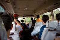 In the bus, enroute to Machame Gate
Day 1 - 30 Sept 2007 | Machame Gate (1500m) - Machame Hut (3000m)
After an early breakfast, we left for the Machame Park gate at about 8AM (1hr drive roughly). The Machame Gate is already 1480m above sea level, so the actual climb up to Uhuru Peak is only about 4400m. It started to rain enroute to the gate which was a bit demoralising, but luckily it cleared when we reached the gate. The weather can be a bit unpredictable so close to the equator.
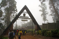 Machame Gate
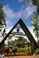 Machame Gate
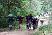
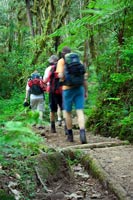
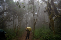
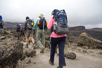
It can get a bit crowded at the gate. All groups are required to register. IMPORTANT: Take down your passport number and keep it with you. You will need it when registering at each camp. If you forgot the odd trekking pole, sun hat or poncho, don't worry. There are locals at the gate trying to flog equipment. I hired one trekking pole which incidentally did not work properly. So I bought one for $13 at the gate. After all the formalities, we started walking at about 11:40! The pace is nice and slow and our guides kept it like that. Soon you realise just how amazing the porters are. You will see them walk past you with your gear bags on their heads. Phenominal.
 Porters
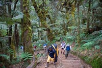
 Rain Forest
 Rain Forest
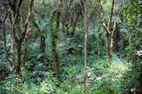
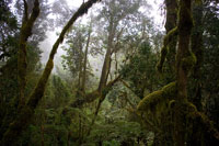
The forest is really quite something. Humid of course. Animal sounds everywhere, although it is difficult to actually see them.
 Rain Forest
 Rain Forest
 Rain Forest
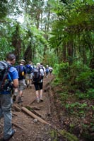
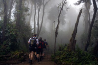
The path was in very good condition. Probably due to the good weather. No gaiters were necessary. No mud anywhere and logs have been put in place.
 Rain Forest
 Rain Forest
 Rain Forest
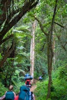
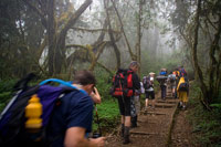
Fog appeared which gave the forest an eerie, magical feeling.
 Rain Forest
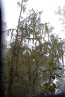 Rain Forest
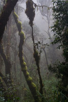 Rain Forest
The walk through the forest was really enjoyable. Just before you reach Machame Hut at 3000m, you start clearing the forest.
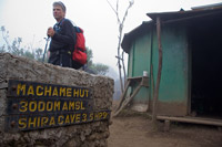 Machame Hut
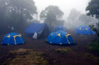 Machame Camp
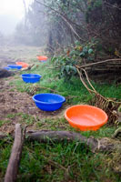 Washing
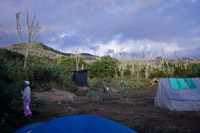
We reached Machame Gate at 16:30. We had to sign in (remember your passport number!) and we were taken to our camp site (the blue tents). There we were given 8 bowls (we were 11 people) of warm water to wash our hands and faces. Anti-bacterial soap was provided. The big blue tent was the mess tent (where we ate).
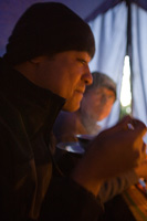 Eating
 Machame Camp
 Eating
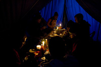
We were given soup and bread. Soon we realised that the soup was going to be the starter for supper each day. Another course always followed. It varied from day to day, but was usually one or more of: pasta with sauce, potatoes, vegetable stew, chips (or fries), chicken, boiled egg and rice. For the bread there was peanut butter and/or honey. To add flavour we had tomato sauce and chilli sauce. Hot drinks were tea, coffee and milo. Powdered milk is provided. You will see a small, dark, wooden building in the center image above. That is "The place we do not speak of". "The things we do not speak of". "The smell we do not speak of". Yes, it is the tiolet facilities... and it is disgusting!
Day 2 - 1 Oct 2007 | Machame Camp (3000m) - Shira Camp (3840m)
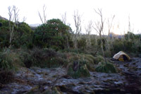 Machame Camp - Morning Frost
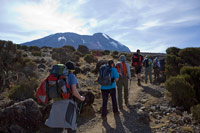
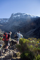
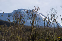 Machame Camp - First View
 Robinson
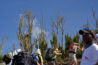
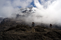
The next morning we had frost all around the tents. The fog cleared and we had our first view of the mountain. We started walking at about 08:30 and were enroute to Shira Camp. This part of the trail is through moorlands and some rocky bits. Some people starting taking Diamox tablets (for altitude sickness). I took some at lunch.
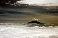
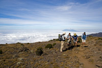
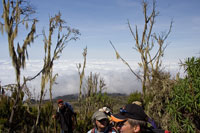 Heading above the clouds
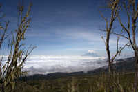 Mt. Meru
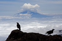 Mt. Meru with crows
We were heading above the lower clouds. In the distance we could see Mt. Meru in Kenya. As soon as you spot crows, you know lunch is close. These creatures have become really tame and they know exactly where to hang around for some left-overs.
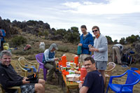 Lunch
Lunch
 Robinson - Moorland
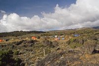 Shira Camp
We had a picnic lunch. Look at that. What service! Tables set and everything. After lunch we continued through the moorlands to Shira camp on the plateau. We reached the camp at about 16:30.
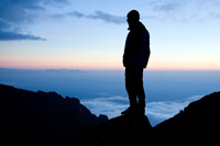
 Shira Camp - Mt. Meru Sunset
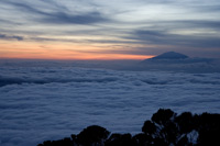 Shira Camp - Mt. Meru Sunset
Great sunset with Mt Meru in the back.
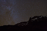
Being that high (almost 4000m) and with no city lights around, the view of the night sky is absolutely fantastic. I managed to fire off a couple of shots using an EOS 350D and a Sigma 20mm f/1.8 lens.
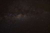 Shira Camp - Milky Way
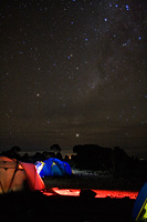 Shira Camp - Milky Way with Tents
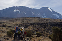
Day 3 - 2 Oct 2007 | Shira Camp (3840m) - Lava Tower (4630m) - Barranco Camp (3950m)
 Start of Day 3 - from Shira
 Leaving Mt Meru behind
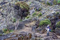
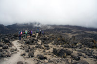
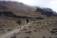
We started walking at roughly 08:30 towards the Western Breach of the mountain. The vegetation becomes less and the scenery turns into a semi-desert with lava rocks everywhere.
 Hiking towards Lava Tower
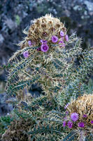
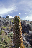 Lobelia plant
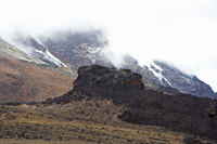
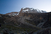
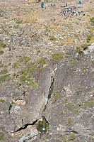
The Western Breach is quite spectacular. Pity that the glaciers are melting at such a rapid rate. At some point we crossed a small stream and our one guide, Robinson, pointed out that the stream did not even exist the previous year. The Arrow Glacier is melting at such a rapid rate.
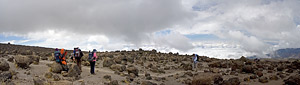 Panoramic of scenery towards Lava Tower
In the panoramic photo above, you get a good idea of the landscape above 4000m.
 Lava rocks
 Lava rocks
 The split towards Lava Tower / shortcut to Barranco
As we slogged towards Lava Tower, I must admit that it became more and more difficult to breathe. I found myself frequently out of breath without even doing much of a physical climb. Some people were also complaining about headaches. The altitude was really starting to affect us. My heart was racing, I was out of breath and I felt really tired. At last we reached the split in the trail. Continue on towards Lava Tower, or take the shortcut down to Barranco. We decided to head on towards Lava Tower.
 Lava Tower in sight
 Lava Tower at 4600m
The trail finally flattens and you can see Lava Tower, a big chunk of lava rock testiment to Kilimanjaro's volcanic history. We reached Lava Tower at about 12:30 where we had lunch. Most of us were pretty tired and not feeling well.
 Enroute to Barranco
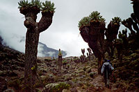
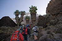
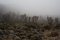
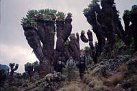 Huge "Senecio Kilimanjari" plants
 Sunset at Barranco
After a short break at Lava Tower (4630m), we descended down towards Barranco Camp. Just before we reached the camp, we encoutered the giant, pre-historic-looking Senecio Kilimanjari plants. These things are huge and apparently one branch takes 25 years to grow. You can clearly see the scale in the picture in the middle (above). We were at Barranco Camp at about 16:30.
 Night sky at Barranco
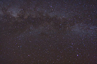 Milky way at Barranco
I had another go at taking some night sky pictures.
Day 4 - 3 Oct 2007 | Barranco Camp (3950m) - Barafu Camp (4550m)
 Start of Day 4 - Barranco
 Start of the hike towards Barranco Wall
 Start of the hike towards Barranco Wall
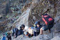
We started at about 08:20. Our first mission was to climb the Great Barranco Wall, a high vertical rock face that looks almost impossible to climb without proper equipment.
 Interesting plant
 Barranco Wall
 Looking back at the camp site from Barranco Wall
The climb became steeper and steeper. Trekking poles are of no use because you occasionally need your hands to hold on to the rocks.
 Some steep areas
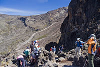 Taking a break. Almost over the wall
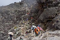
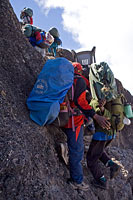 The porters on the Barranco Wall
It is truly amazing to see the porters go up Barranco Wall. With chairs and gear bags on their heads they managed to get up there quicker than we did!
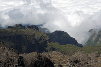 The valley below from the Barranco Wall
 Over the Barranco Wall
 The Heim glacier
We finally conquered the Barranco Wall and were now just below the Heim glacier. Heavy fog appeared and for the rest of the trail up to lunch, we could not see much. We had to endure some more up-hill and down-hill sections. We were quite disappointed when we realised that lunch was at an altitude 40m below where we started at Barranco Camp! That meant that that after lunch we would still have to do another 600m vertical climb to Barafu Camp!
 Some more "Senecio Kilimanjari"
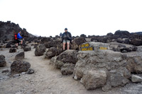
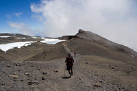
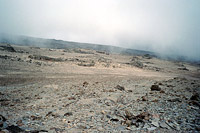 The Alpine Desert towards Barafu
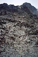 Strange landscape with chipped rocks everywhere
The hike from lunch to Barafu was tiring. We hiked through the alpine desert landscape, which looked like it could have been on Mars. After more steep up-hill sections and constant lack of oxygen, we finally reached Barafu Camp (4550m).
 The Alpine Desert towards Barafu
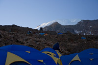 Barafu Camp
We arrived there quite late, about 17:30. We were all very tired, had supper at 19:00 and had to somehow try and get some sleep for the final push to the summit at 0:00. We only had about 3 hours to get some rest, from about 20:00 until 23:00. It was pretty pointless. I think I only managed about 1hr of sleep.
Day 5 - 4 Oct 2007 | Barafu Camp (4550m) - Uhuru Peak (5895m) - Millennium Camp (4000m)
Summit day finally arrived! We started hiking at about 00:30. All you can see in the darkness of night are trails of headlamps infront of you. The starry sky, the cold and the headlamps create a strange surreal feeling. We barely started our hike when we encountered other groups' guides walking down with individuals who did not make it. Almost half of one group infront of us were taken down to Barafu Camp due to altitude sickness. Half way up to Stella Point (the crater rim), I was seriously out of breath. I had to calm myself down not to panic. Easy does it. Just ten small baby steps, while gasping for air and then rest while. I could never catch my breath. my breathing was really shallow and I could just feel that my muslces were not getting nearly enough oxygen to function properly. I realised what it must feel like being 100 years old in an old-age home. Small, small baby steps with two trekking poles and then having to rest after ten such steps. Gasping for air. The sun came up. I was disappointed, because I thought we were going to see the sun rise at the peak. When I reached Stella Point on the crater rim, I can honestly say that I have never been so tired in my entire life. I knew it was only due to lack of oxygen. The last 200-300m up towards Stella Point was really the hardest. From Sella Point you can see Uhuru Peak across the Kibo crater. It is only about another 100m vertically upwards, but it was really amazing how long it took and how difficult it was to get there.
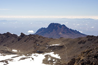 View of Kibo and Stella Point from the crater rim
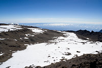 View of the crater from the rim
In the images above you can see the Kibo crater.
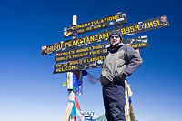 Uhuru Peak, the highest point in Africa
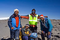 Our guides: Kassim, Davis, Robinson, Godfrey
Finally we reached Uhuru Peak!!! It took us long enough, we reached the peak at 09:30! It was a strange feeling to be there. Everyone was too tired to rejoice. I did not even read the sign. I forgot, or I was not interested. Your brain switches off a little. We were at the highest point in Africa, and it was almost as if we did not realise it at the time. I would talk to some of the other people in the group and they simply would not respond. I kept getting my camera settings wrong. Really strange. Some of us wanted to lie down, but our guides pulled us up immediately and warned us not to.
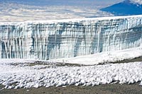
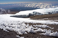
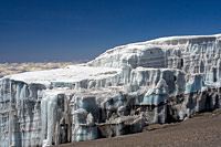 Southern Ice Fields - Rebmann Glacier
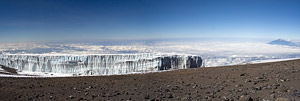 Southern Ice Fields - Rebmann Glacier
Luckily I realised that I had to take some more pictures. The Rebmann glacier was right next to the peak.
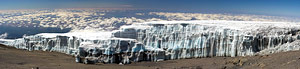 Southern Ice Fields - Rebmann Glacier
 Southern Ice Fields - Rebmann Glacier
Some more pictures of the glacier.
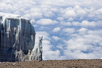
 Southern Ice Fields - Rebmann Glacier
 Southern Ice Fields - Rebmann Glacier
I only took pictures of this one glacier. I was really disappointed that I did not have the strength to continue walking onwards from Uhuru Peak towards the Northern Ice Fields. Perhaps I should have forced myself to.
 Walking back along the crater rim
After about 15-20 minutes, we started walking back to Barafu Camp.
Day 6 - 5 Oct 2007 - Last Day
The last day takes us from Mweka Camp at 3100m down to Mweka Gate at 1450m. The 3-hour descent is again through the rain forest and it is apparently very scenic.
AND THAT'S IT! I hope you will join us for a daily trip update on the Live Blog page (listed under the menu above).